Project details

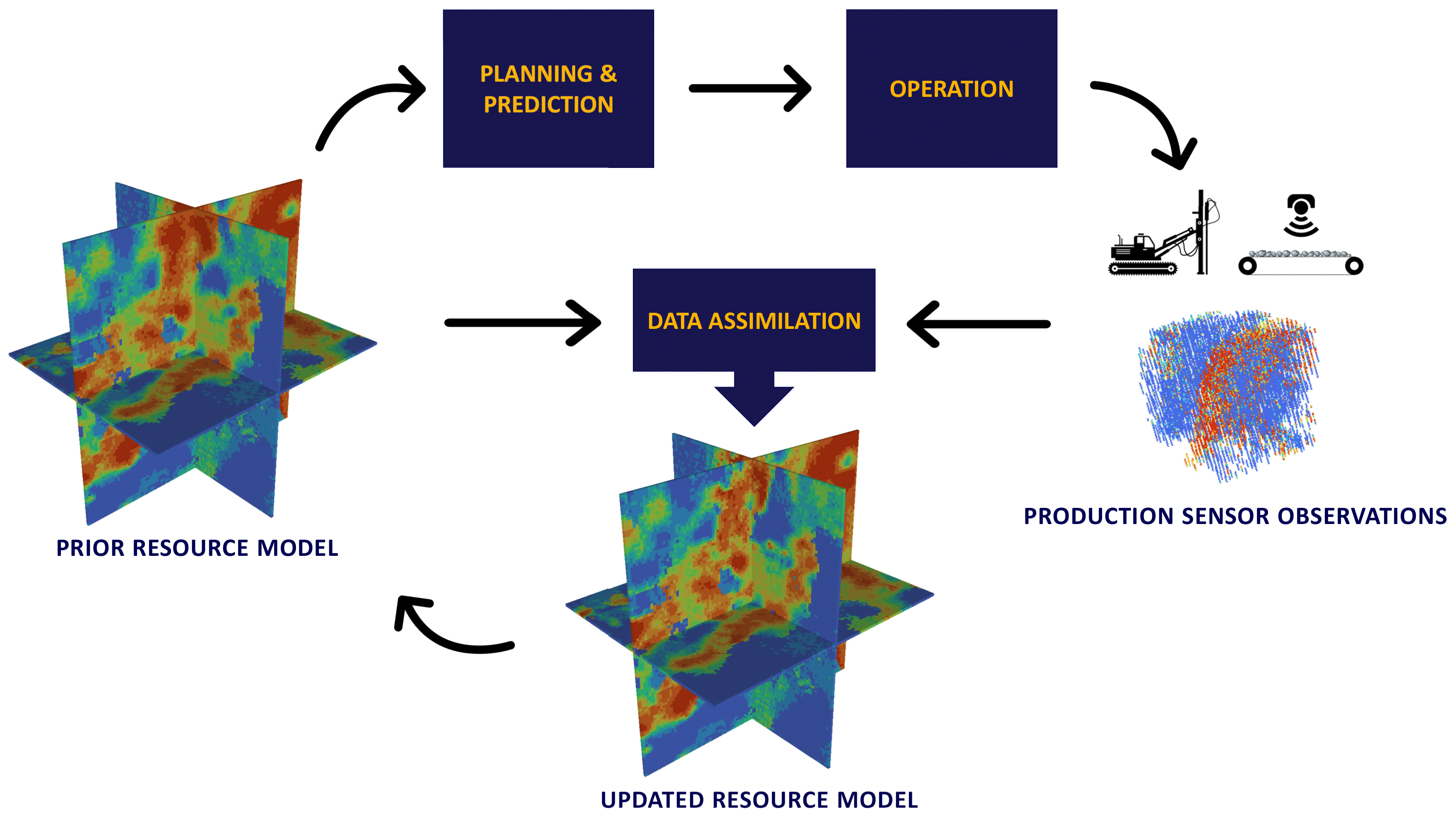
Approach: Rapid, stochastic updating of resource models with sensor information for high resolution reconciliation and rapid decision-making.

This project focuses on rapidly updating the resource knowledge with upstream (drill) and downstream (belt) sensor information, with partner company Maptek. The upstream and downstream information constrains the resource knowledge close to the mining stage and allows rapid reconciliation of the ore attributes for upstream and downstream use.

Resource models are generally constructed from directly observed data (e.g., grades of drill cores) that have relatively high accuracy. Resource models are, however, limited by the scale on which the data are collected. As mining progresses more information becomes available on different scales from various types and sources of data. Drill cuttings from blast holes provide in situ data on smaller scales. Sensors on drilling rigs and on conveyor belts provide data in near real-time as do draw-point sensing and Load Haul Dump (LHD) sensors.

All these types of data – drill core, drill sensors, draw-point sensors, LHD sensors, belt sensors – measure different volumes in different ways and have different levels of accuracy, all of which must be accounted for when integrating the various types of data. Although most data will be quantitative (e.g., grades) some will be qualitative (e.g., structures such as geology or domain types). Integrating these types of data requires a stochastic approach to account for the different levels of accuracy (uncertainty) and the different volumes of measurement. To enable rapid decision-making, the resource model must be updated with newly acquired data in near real-time.

The project is calibrating the various types of data, integrating/fusing the data and developing and adapting methods for rapidly (near real-time) updating resource models with newly acquired data. Data integration includes accounting for the different levels of uncertainty of the various types of data (1, 2, 3, 4). Methods that are being explored for updating resource models include the various forms of the Kalman filter (5, 6).

Image based on work done by Dr Exequiel Sepúlveda.

Researcher

Sultan Abulkhair

Location

University of Adelaide

Key Contacts

Principal Supervisor:
Professor Peter Dowd

Email:
peter.dowd
@adelaide.edu.au

Ph: +61 08 8313 4543

Co-supervisors:
Associate Professor Chaoshui Xu
Professor Frank Neumann

Supervisor Profile

Publications

Abulkhair, S., Dowd, P.A., Xu, C., 2023. Geostatistics in the Presence of Multivariate Complexities: Comparison of Multi-Gaussian Transforms. Mathematical Geosciences, 55, pp. 713-734. https://doi.org/10.1007/s11004-023-10056-y

Abulkhair, S., Madani, N. 2022. Stochastic modelling of iron in coal seams using two-point and multiple-point geostatistics: A case study. Mining, Metallurgy & Exploration, 39, 1313–1331. https://doi.org/10.1007/s42461-022-00586-0

Abulkhair, S., Madani, N. 2021. Assessing heterotopic searching strategy in hierarchical co-simulation for modelling the variables with inequality constraints. Comptes Rendus. Géoscience, 353(1), 115-134. https://doi.org/10.5802/crgeos.58

References

(1) Soares, A., Nunes, R. and Azevedo, L. (2017) Integration of uncertain data in geostatistical modelling. Mathematical Geostatistics, 49, 253-273.
(2) Dowd, P.A. and Pardo-Igúzquiza, E. (2006) Core-log integration: optimal geostatistical signal reconstruction from secondary information. Applied Earth Sciences, 115, (2), 59-70.
(3) Dowd, P.A. and Pardo-Igúzquiza, E. (2005) Estimating the boundary surface between geological formations from 3D seismic data using neural networks and geostatistics. Geophysics, 70, (1), 1-12.
(4) Adeli, A., Emery, X. and Dowd, P.A. (2018) Geological modelling and validation of geological interpretations via simulation and classification of quantitative covariates. Minerals, 8 (1): 7, doi:10.3390/min8010007
(5) Benndorf, J. and Buxton, M.W.N. (2016) Sensor-based real-time resource model reconciliation for improved mine production control – a conceptual framework. Mining Technology, 125:1, 54-64, DOI: 10.1080/14749009.2015.1107342
(6) Wambeke, T. and Benndorf, J. (2017) A simulation-based geostatistical approach to real-time reconciliation of the grade control model. Mathematical Geosciences, 49, 1 -37.

Industry Partners